Snowfall Forecast: Saturday Night Storm Approaching Massachusetts
As southern New England prepares for the arrival of a nor’easter this weekend, the WBZ weather team is on high alert, tracking important updates and forecasts for the region.
Key Changes:
Shift in Timing: The storm’s start and heaviest snowfall periods are expected to commence a bit earlier than previously forecasted.
Snow on Sunday: Although snowfall will persist on Sunday, it might be lighter and struggle to accumulate in areas near or east of I-95, where temperatures might hover around or above freezing, mixing with rain.
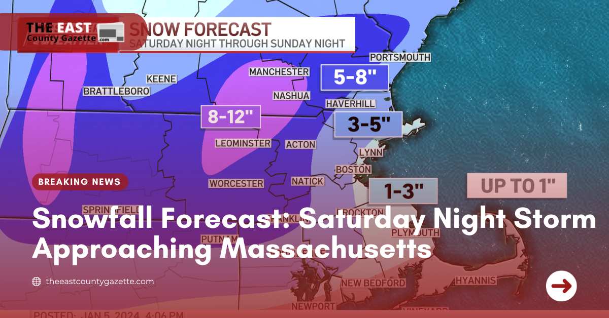
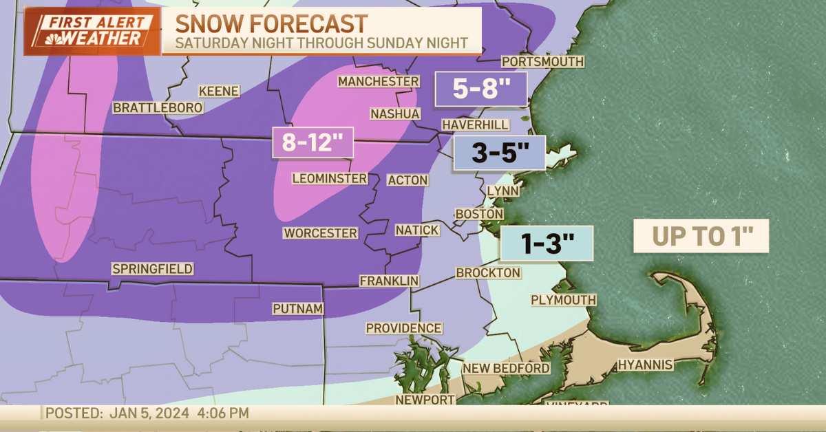
Snow Accumulation: The highest snowfall totals are anticipated in the Merrimack Valley and Worcester County, north and west of Boston.
Storm to arrive Saturday night, how much snow will Massachusetts and Boston get?
Storm to arrive Saturday night, how much snow will Massachusetts and Boston get?https://t.co/o4MPWw5zU1
— WBZ | CBS News Boston (@wbz) January 5, 2024
Weather Warnings:
The National Weather Service has issued a Winter Storm Warning for most of Essex, Middlesex, and Worcester Counties from Saturday evening through Sunday.
These areas face the highest risk of accumulating at least 6 inches of snow.
Storm Arrival and Details:
- The snow is now projected to arrive earlier, between 6 p.m. and 10 p.m. on Saturday night.
- Once it begins, snowfall rates may be heavy, reaching or exceeding 1 inch per hour in some heavier bands.
- Snow intensity will decrease on Sunday, with the storm tapering off between 4 p.m. and 6 p.m., starting from the western regions.
Snowfall Predictions:
Snow accumulation forecasts vary across different regions:
- 6-10 inches: Areas north and west of I-95, encompassing Essex, Middlesex, and Worcester Counties, potentially even up to 12 inches in isolated spots.
- 3-6 inches: Surrounding areas around 128 extending into northern Plymouth and Bristol Counties.
- 1-3 inches: Immediate coastal areas from Cape Ann to Boston, including the South Shore and Cape Cod Canal.
- Little to no snow expected on the Outer Cape and Nantucket.
Weather Conditions:
- Coastal winds may peak between 35-55 mph, potentially causing scattered power outages in areas with heavy, wet snow and gusty wind.
- Coastal flooding threats are low this weekend due to astronomically low tides.
Check out these recent headlines:
- Winter Storm Alert: Northeast, Mid-Atlantic on High Alert
- Appalachian Power on High Alert for Winter Storm
- Over 10 Million Americans Get Winter Weather Alerts After Thanksgiving Storm
Flash Freeze and Patriots Game:
- The storm on Sunday afternoon will bring a flash freeze as temperatures plummet, causing untreated surfaces to ice up.
- For the Patriots’ final home game, expect light snow and dropping temperatures from the low 30s into the 20s.
Next Storm Forecast:
Brace for another storm late Tuesday, potentially starting as a mix and transitioning into a rainstorm, leading to potential flooding with several inches of rain expected Tuesday night into Wednesday.