A significant winter system is expected to hit the Chicago area on Thursday, bringing high wind gusts, dangerous wind chills, and natural snowfall. Shallow temperatures, with wind chills as low as -35 degrees below zero, will threaten anyone venturing outdoors during the snowstorm and high winds.
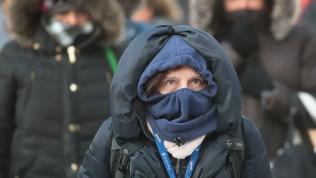
Even if the snow doesn’t seem like much, experts have warned that getting around and being out in the elements will be extremely risky when the snow is falling. When the temperature is well below zero, frostbite on the hands can set in in a matter of minutes, according to Dr. Trevor Lewis of Cook County Health.
Lewis elaborated by saying that shivering is the body’s natural way of warming up and that it serves as a warning to anyone out in the cold to come inside as soon as possible and shed any wet clothing.
A 2004 study conducted by researchers at three universities found that a fur-lined hood is the most effective way to combat the cold if you must be outdoors. Researchers found that Inuit seamstresses and hunters have been using the same fur-lined hood pattern for millennia.
McHenry, DeKalb, Kane, LaSalle, Kendall, and Grundy counties will be under a winter storm warning starting at 9 a.m. on Thursday, per the NWS. The Illinois counties of Lake, DuPage, Kankakee, Cook, and Will, as well as the northwest Indiana counties of Lake, Newton, and Jasper, will be affected by the warning at noon CT.
A blizzard warning is in effect from Thursday at 3 pm CT through Saturday at 6 am CT for Porter County in Indiana. The National Weather Service pointed out that the criteria for issuing such a warning are not the accumulations of snow but the winds and the visibility.
However, as of Wednesday afternoon, NBC 5 Storm Team Meteorologist Paul Deanno said the worst of the storm is expected to hit between 8 p.m. Thursday and 12 p.m. Friday, though some locations may experience “rapidly deteriorating” travel conditions much earlier in the afternoon.
There is a risk that the wintry system will hit late Thursday morning in some suburbs to the northwest, west, and southwest of Chicago, making driving and visibility conditions hazardous.
The National Weather Service predicts “brutal” travel conditions Thursday afternoon and Friday morning due to the possibility of a blizzard.
Deanno predicted that even after the snow stopped blowing, the winds would remain strong. As a result, snow will be blown in all directions, giving the impression that it is still snowing. Our current state of knowledge is as follows:
When Does Snow Usually Start Falling?
Snow is now predicted to fall in northwest Illinois on Wednesday night, according to forecasters. However, the natural snow will start Thursday morning in the western part of the area and then move east toward the city by the early afternoon.
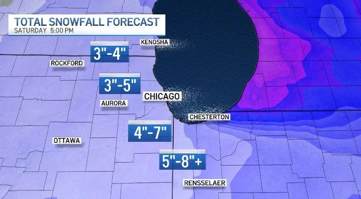
How much snow can we expect?
If the predicted snowfall amounts don’t seem like much, remember that “it’s not just the snow,” as Deanno put it. This is due to the dangerously low temperatures from the snow, high winds, and wind chills.
Forecasts continue to change leading up to the event, but some areas could get more than 8 inches of snow, and others could get closer to 3 inches. Deanno also mentioned that wind could affect the amount of snow that melts away in your region. Some areas may get several inches of snow, but that may not be the total that sticks around because of the strong winds.
Worsening Weather Makes Travel Dangerous
At the height of the storm, the National Weather Service is warning drivers and passengers that conditions on the roads could be “life-threatening.” This includes both long-distance travelers and those going short distances.
Illinois State Police issued a statement on Wednesday afternoon urging residents to “stay off the roadways for the next couple of days during the severe winter weather expected to begin [Thursday].”
“If you must travel, give yourself plenty of time to get where you’re going and keep your attention on the road at all times. Take it easy and make room on the road for disabled and emergency vehicles, “I got the message.
The Illinois Tollway has announced that extra personnel will be on hand in anticipation of the storm.
In a statement, Illinois Tollway Executive Director Cassaundra Rouse said, “Our top priority during this storm will be keeping our customers safe by operating our plows around the clock to rapidly remove snow and ice from our roads and by quickly responding to any drivers whose vehicles become disabled on our system during this severe weather.” Customers can help us keep them safe by reducing their speed, giving snowplows more space than usual to do their jobs, and planning extra travel time.
This storm occurs during the peak travel season. Between December 23 and January 2, approximately 113 million Americans, including 5.8 million in Illinois, are expected to travel 50 or more miles. The Illinois Tollway anticipates 1.7 million vehicles on the system on Wednesday and Thursday alone.
WINTER WEATHER IN CHICAGO ON DECEMBER 20
Find Out What to Do If You Get Stranded in a Snowstorm. Here is What the Professionals Suggest
THE SNOW IN CHICAGO
DEC 20
Reasons Why This Winter’s Predicted Snowfall May Not Be Accurate
The Chicago Department of Aviation estimates that between December 21 and January 2, roughly 2.9 million passengers will fly through O’Hare and Midway International Airports.
How Do Blizzard Conditions Work?
The NBC 5 Storm Team defines a blizzard as a set of circumstances that are extremely rare. Conditions like these involve snow or blowing snow, winds of at least 35 miles per hour, and visibility of 300 feet or less.
According to NBC 5’s meteorologists, a storm can only be classified as a blizzard if all three factors are present for at least three hours.
The National Weather Service reports that the snowiest Christmas in the Chicago area was in 1950 when the city received more than five inches of snow.